El Niño 2026
This Year’s El Niño Is Huge and Already Changing the World was a recent headline in the New York Times. This blog will offer some insight from scientists around the world as to exactly what that headline means and how it will affect multiple locations throughout the world.
El Niño is a recurring climate phenomenon which scrambles weather patterns, spikes global temperatures and usually doesn’t reach full strength until December. Leading climate scientists expect that by December this El Niño will wind up as the strongest in at least 80 years of record-keeping. And perhaps as the most powerful in centuries. It is only the beginning of October, and it is already extremely strong and having major effects on several continents. It is causing extreme rises in temperature, dry spells and crop failures. The United Nations World Food Program has said that an additional 49 million people will be driven into hunger as a result of the effects of this El Nino.
The on-the-ground consequences we are already witnessing reflect the magnitude of the changes in the Pacific Ocean, where El Niños develop when unusually warm waters build up. These episodes occur every two to seven years and have contributed to planetary swings going back millenniums.
Scientists are debating whether human-caused climate change is tilting the odds toward stronger and more frequent El Niño events. What is clear is that El Niño’s gyrations are adding to the stronger storms, drier dry spells and fiercer wildfires that global warming is already bringing about. El Niño will magnify those phenomena in some regions and could lift global temperatures to record levels next year, as the heat from the Pacific spreads around the world.
“What we’ll see in 2027 is a sneak peek of what the new normal will be in 2035,” said Zeke Hausfather, a climate scientist at Berkeley Earth, a nonprofit research organization. “We’ll see things that have never happened before in our history in terms of temperature, drought conditions, and extreme heat.”
El Niño events are measured by looking at sea surface temperatures in a specific rectangular zone of the Pacific Ocean. Temperatures there have soared over the past three months, and forecasts suggest that, by year’s end, they could exceed normal levels by more than they did during the strongest El Niños in modern history, which occurred in 1982-83, 1997-98 and 2015-16.
Between October and December, the National Oceanic and Atmospheric Administration says there’s an 81 percent chance that El Niño conditions will be “very strong,” meaning the three-month average temperature in that zone of the Pacific is 2 degrees Celsius, or 3.6 degrees Fahrenheit, higher than normal. But forecasts show that daily ocean temperatures during that period could spike to more than 3 degrees Celsius above normal.
“Maybe it doesn’t sound that big: three or even four degrees. We see that temperature variation over the course of a day,” said Samantha Stevenson-Karl, an associate professor and climate modeler at the University of California, Santa Barbara. “But the ocean doesn’t change that much. Like, ever.”
The extra heat in the waters of the Pacific affects air temperatures, too. For the first months of the year, 2026 was clearly cooler than 2024, the planet’s hottest year on record. But Dr. Hausfather still gives 2026 a 40 percent chance of being Earth’s warmest year on the books, a sign of how the pendulum could be swinging. According to NOAA, July 2024 tied as the world’s warmest July since global record-keeping began in 1850. The first half of this year, while broadly hotter than in previous decades, generally did not approach the heat records set in 2024. But the summer months have been warmer than comparable dates in any prior year.
The heat that builds up near the surface of the tropical Pacific eventually makes the entire planet warmer. The trend takes a while to materialize, but recent El Niños have led to annual global heat records in the year after they form. To that end, scientists broadly expect 2027 to be the hottest year humans have ever experienced. But the heat is altering the trajectory of 2026 as well.
Scientists measure El Niño’s strength with the Oceanic Niño Index (ONI) – the three-month average of how far Pacific sea-surface temperatures sit above normal. A weak El Niño runs around +0.5 to +1.0°C. Once the index reaches or passes +2.0°C, forecasters call the event “very strong,” or informally, a “Super” El Niño.
Forecasters give the 2026–27 event roughly an 88% chance of reaching “very strong,” according to the NOAA Climate Prediction Center. That’s a forecast, not a settled fact – the odds are updated as new seasonal outlooks come out, and elninoimpact.com tracks the live strength reading using NOAA’s Oceanic Niño Index (ONI).
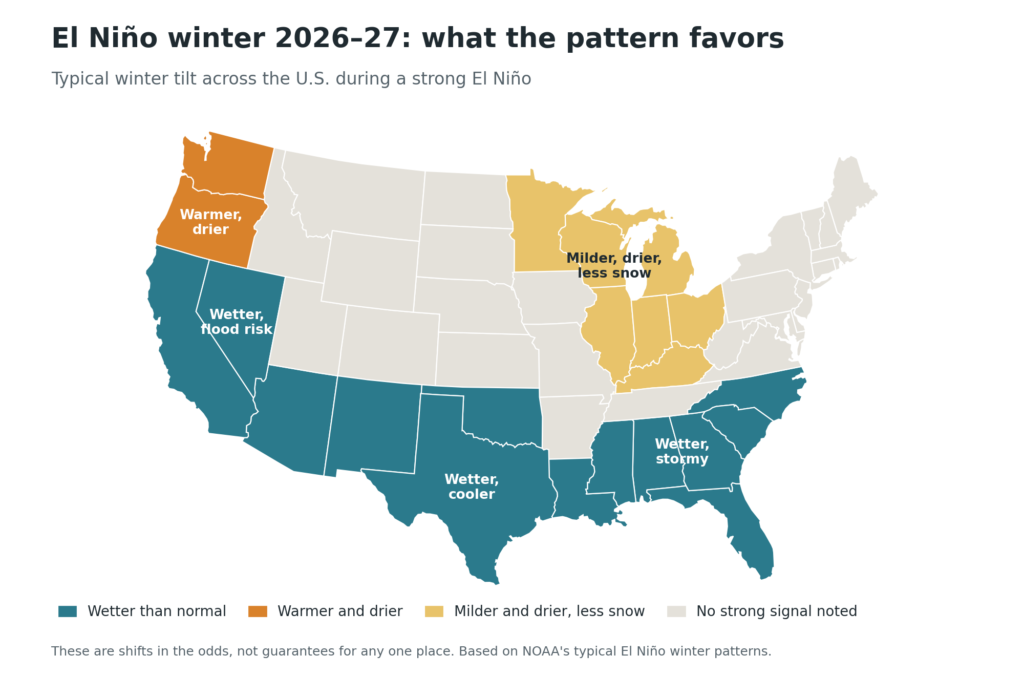
While scientists cannot speak with absolute certainty about how the 2026 El Niño will affect the United States, based on what they do know they have predicted the following:
“El Niño steers the Pacific storm track south over California, Arizona, Nevada and New Mexico – NOAA rates the Southwest among the most reliable wet-winter signals in the U.S. A very strong event is tied to the wettest Southwest winters on record (1982–83, 1997–98, 2015–16), raising the risk of flooding and landslides, especially below burn scars and hillsides.
El Niño strengthens the subtropical jet over Texas, Oklahoma, Louisiana, and the wider Gulf Coast, favoring a wetter, slightly cooler winter. Saturated ground and frequent storm systems raise the risk of street and river flooding through the season.
The same strengthened subtropical jet brings frequent rain and storms across Georgia, the Carolinas, Alabama and Florida. NOAA’s outlook favors above-normal rainfall from October through March, with flood risk rising in low-lying coastal areas.
El Niño pushes the wettest Pacific storms south of Washington and Oregon, favoring a warmer, drier winter. Strong events have averaged Washington Cascades snowpack near 75% of normal, meaning tighter summer water supply and earlier wildfire risk.
El Niño winters shift the storm track south, leaving the upper Midwest, Great Lakes and Ohio Valley milder and drier than normal with below-normal snowfall – one of the most consistent U.S. ENSO signals. Expect reduced snowpack and spring water supply, with occasional sharp cold snaps still possible.”
Right now, the world is entering a new El Niño phase. As researchers indicate that it could be one of the strongest on record, they are citing the history of El Niños as a warning that natural forces, when they reach their highest magnitude, can lead to profound volatility and hardship.
Sources
https://www.elninoimpact.com/2026-super-el-nino
https://weather.com/news/climate/news/2026-04-15-super-el-nino-effects-temperature
Carbon Rangers / Ecozoic Times
Vol. 19, No. 7
September, 2026
The New York Times. “A Powerful El Niño Is Forming. If History Is a Guide, It Could Hit Hard”. May 26, 2026.
The New York Times. “This Year’s El Niño Is Huge and Already Changing the World”.
August 12, 2026 by Raymond Zhong and Chico Harlan.

Protected by Comments Firewall